


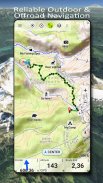
US Topo Maps
Опис програми US Topo Maps
Простий у користуванні навігаційний додаток із безкоштовним доступом до найкращих наявних карт і аерофотознімків США.
Вибирайте між 30+ шарами карт (топоси, антени, морські карти тощо), щоб спланувати ідеальну подорож і
Перетворіть свій телефон/планшет Andoid на відкритий GPS для офлайн-подорожей у глуху місцевість.
Легко додавайте карти з інших джерел (GeoPDF, GeoTiff, онлайнові картографічні служби, такі як WMS, ...)
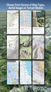
Доступні шари базової карти для США:
• Національна карта USGS Topo
• Топозображень національної карти USGS
• Зображення національної карти USGS
• USGS NAIP HiRes зображення
• USGS Topo традиційні DRG: безперебійне покриття топографічних карт США в масштабах 1:250 000, 1:100 000, 1:63 000 і 1:24 000/25 000
• Карти лісів FSTopo
• Морські карти NOAA
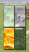
• Національні карти висот (відтінок, карта схилів, карта аспектів)
Шари базової карти світу:
• OpenStreetMaps (5 різних макетів карт), також можна завантажити у векторному форматі, що економить місце
• Карти Google (супутникові зображення, карти доріг і місцевості)
• Карти Bing (супутникові зображення, дорожня карта)
• Земля вночі
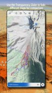
Налаштуйте шар базової карти як накладання та використовуйте фейдер прозорості, щоб легко порівнювати карти між собою.
Додайте карти з інших джерел:
• Імпорт растрових карт у GeoPDF, GeoTiff, MBTiles або Ozi (Oziexplorer OZF2 & OZF3)
• Додайте веб-картографічні служби як WMS або WMTS/Tileserver
• Імпорт OpenStreetMaps у векторному форматі, наприклад, повні США лише за кілька ГБ
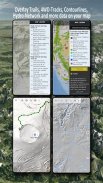
Доступні накладки на карту США - додайте додаткову інформацію до будь-якої іншої базової карти:
• Державна власність на землю (PAD-US 3)
• Національний набір гідрографічних даних
• Карта використання автотранспорту (USDA)
• Контурні лінії висоти
• Траси 4WD
• Стежки
• Дороги, залізниці, аеропорти
Доступні накладки по всьому світу:
• Накладка для відтінку пагорбів
• контури 20 м
• OpenSeaMap
Немає ідеальної карти. Перемикайтеся між різними шарами карти або використовуйте функцію порівняння карт, щоб знайти найцікавіший маршрут. Особливо старі традиційні DRG містять багато маленьких шляхів або інших елементів, яких немає на сучасних картах.
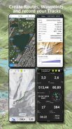
Основні функції зовнішньої навігації:
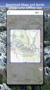
• Завантажте дані карти для ВИКОРИСТАННЯ В ОФЛАЙН
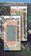
• Вимірювання шляхів і площ
• Створення та редагування маршрутних точок
• GoTo-Waypoint-Navigation
• Створення та редагування маршрутів
• Навігація по маршруту (навігація від точки до точки)
• Запис треку (з профілем швидкості, висоти та точності)
• Tripmaster з полями для одометра, середньої швидкості, азимуту, висоти тощо.
• Імпорт/експорт GPX/KML/KMZ
• Пошук (назви місць, POI, вулиці)
• Отримайте висоту та відстань
• Настроювані поля даних у Map View і Tripmaster (наприклад, швидкість, відстань, компас, ...)
• Діліться маршрутними точками, треками або маршрутами (через електронну пошту, Dropbox, WhatsApp, ..)
• Використовуйте координати в WGS84, UTM або MGRS/USNG (Військова мережа/ Національна мережа США),
• Повтор доріжки
• та багато іншого ...
Використовуйте цю навігаційну програму для заходів на свіжому повітрі, як-от походів, їзди на велосипеді, кемпінгу, скелелазіння, верхової їзди, катання на лижах, веслування на каное, полювання, турів на снігоходах, позашляхових турів із повним приводом або пошуково-рятувальних робіт (SAR).
Додайте власні маршрутні точки у форматі довготи/широти, UTM або MGRS/USNG із датумом WGS84.
Імпорт/експорт/обмін GPS-маршрутними точками/треками/маршрутами у форматі GPX або Google Earth KML/KMZ.
Дивіться анімований дощовий радар NEXRAD, щоб робити точні прогнози, коли почнеться або припиниться дощ
Будь ласка, надсилайте запитання, коментарі та запити щодо функцій на support@atlogis.com
US Topo Maps – Версія 7.8.0
(08-05-2025)US Topo Maps - інформація про APK
Версія APK: 7.8.0ID пакета: com.atlogis.northamerica.freeОстання версія US Topo Maps
Інші версії


 3.55
3.55


Додатки в цій категорії

Вам також може сподобатися...


